
Earth Observation & GIS Applications
“Seizing Opportunities in Maritime-Space Information”
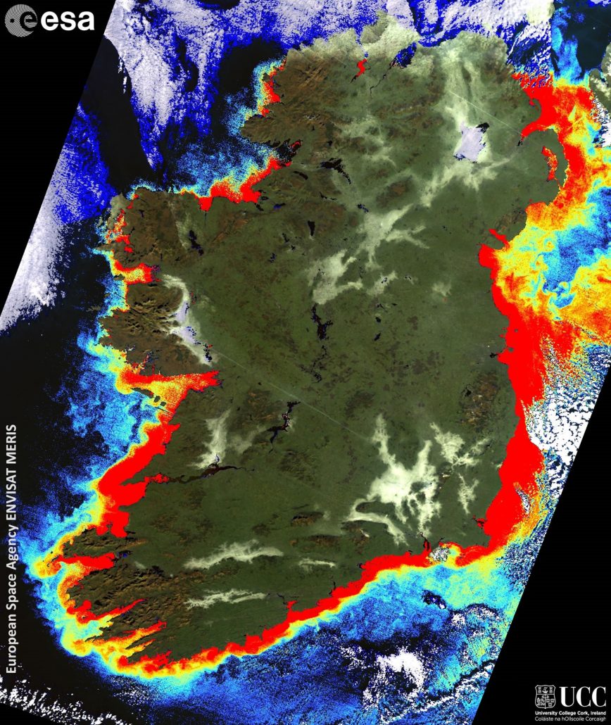
Expanding satellite fleets such as Europe’s Sentinel systems, and the vast quantities of data they collect, provide a huge challenge, and opportunity to Ireland’s maritime sector in terms of information for science and society. The Earth Observation (EO) and Geographical Information Systems (GIS) Applications team are focused on extracting information from this EO (satellite-derived) and spatial data, delivering it to those that need it in a form that is useful to them. Embedded within the Governance thematic grouping, the team are very much at the forefront of targeted information extraction and delivery. This ensures our research is very much applied, serving industry, communities, and science.
The work of the Earth Observation and GIS team actively exploits the opportunity space that exists between the maritime arena, and the Space technology sector, and enabled by the European Space Agency (EOEP, IAP and DUE Programmes), National (EPA), and European funding schemes (FP-7 & H2020). Researching in such a fast-paced environment the group are always willing to engage with new ideas and explore new avenues of research which enhance our core research focuses.
Contact Rory Scarrott for further information.
Core Research Areas Include
- Information extraction, data processing and validation (SAR, Optical, Altimetry, Thermal),
- Marine ecology science support – in particular focused on the fisheries and aquaculture sectors,
- Space Strategy, Maritime Safety and Security,
- Coastal land-cover, land-use, and seasonality mapping,
- Capacity building (EO training) and science support,
- Decision Support and web-GIS applications,
- Climate Information services,
- Science communication, teaching, and public outreach.
Applied Information Integration
Deciding on optimal options requires multiple sources of information to be considered. This is a key focal point for directing how MaREI’s EO & GIS Applications team do their research. The researchers regularly deploy their skills in advanced spatial analyses, geo-statistics, and web-GIS within their applied research, using the cutting-edge GIS technologies available through partner institutes. Through the Marine Irish Digital Atlas (MIDA), and their leadership of the International Coastal Atlas Network (ICAN), the team are kept at the forefront of international metadata standards, coastal decision support needs and tailored applications, and data integration and information display. Being integrated closely with MaREI’s Governance research has also enabled the GIS researchers to excel in visual information presentation and delivery modes and techniques.
Ongoing Projects
- SAFI: Supporting out Aquaculture and Fisheries Industry
- CINMarS: Combining Innovation Networks in Maritime and Space
- Co-ReSyF: Coastal Waters Research Synergy Framework
- C-TEP: Coastal Thematic Exploitation Platform
- PIPS: Developing a tool to predict seabird vulnerability to oil pollution
- MIDA: Marine Irish Digital Atlas
- CCI Soil Moisture
- MarIA: Marine Integrated Applications
- eSurge: Earth Observation for Storm Surge Modelling and Forecasting
- EODAT:
- SeaSearch:
Former Projects
- NG -RMP: (Next Generation Recognised Maritime Picture),
- ANISTIAMO : (Addressing New challenges in Satellite Based Maritime Surveillance and Arctic Monitoring),
- Phenology Impacts on Ireland,
- Planforbio: Planning and Management Tools for Biodiversity in a Range of Irish Forests
- South and East Cork Area Development Community Trails Project
- Cork Harbour Oil-Spill GIS